Military Mule Track of Monteaperta
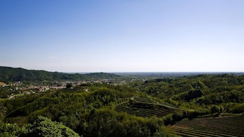
From Monteaperta, a trail (CAI 711) leads towards Gran Monte, following the route of an old military mule track up to a saddle (1,529 m a.s.l.), and then descends into the Musi Valley. From the saddle, another trail (CAI 742) continues along the ridge towards Punta di Montemaggiore. After passing the first peak, there is a frontier barracks built before World War I, used to monitor the border between the Kingdom of Italy and the Austro-Hungarian Empire. The mule track descends towards the building, while the CAI 742 trail continues up to Punta di Montemaggiore (1,613 m a.s.l.), then descends to the village. After the defeat of Caporetto, the Punta became the cornerstone of the new Italian defensive line; its abandonment led to the collapse of the Italian front, forcing a retreat beyond the Tagliamento River. The Gran Monte range is the first group of mountains in the Julian Prealps that exceed 1 600 meters in height. From these peaks, the view is spectacular, spanning from the plain to the Julian Alps. The over one thousand meters of altitude variation are significant for the diversity of plant species: carbonate-soil meadows interspersed with thermophilic forest formations of black hornbeam and downy oak; there are also plantations of black pine forests. From the valley floor, the mown meadow gives way to arid mountain pasture meadow and the subalpine prairie; the upper part features mountain pine shrubs with rhododendron and mountain willow groves with green alder.

A.N.A. Hut
ph. Giorgio Bianchi, Archive MCC

A.N.A. Hut,
Archive Comune di Taipana

ph. Giorgio Bianchi, Archive MCC

Archive Comune di Taipana